North Carolina's Gerrymandering Decision Carries Truly Delicious Consequences
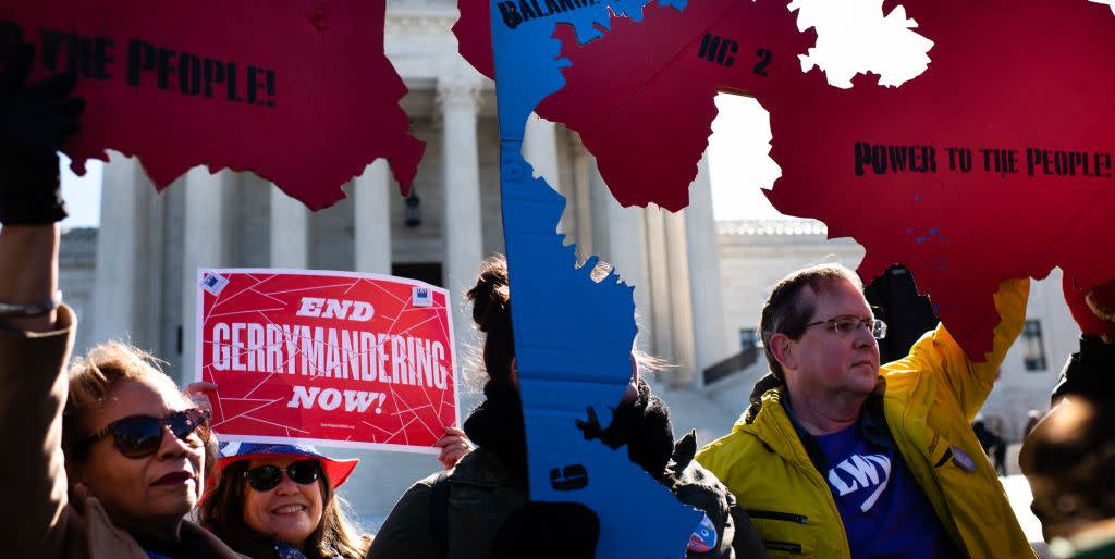
In July of 2016, a federal appeals court struck down a map of legislative districts drawn by the Republican majority in the North Carolina state legislature. In doing so, the court said that the profoundly gerrymandered map had targeted African American citizens "with almost surgical precision," which, in the usually polite parlance of judicial opinions, is the equivalent of hitting the losing party in the lawsuit over the head with a hockey stick.
Late Tuesday afternoon, the North Carolina state supreme court made that previous opinion look like a swat with a feather duster. In a whopping 357-page opinion, the court dropped the big one. From the New York Times:
In outlawing the partisan maps, the judges relied heavily on a broad reading of Section 10 of the State Constitution, which states in its entirety that “All elections shall be free.” While higher state courts have said little about the clause, they wrote, other rulings have made it clear that citizens express their will at the ballot box and that the state has a compelling interest in keeping the vote fair. “The free elections clause of the North Carolina constitution guarantees that all elections must be conducted freely and honestly to ascertain, fairly and truthfully, the will of the people,” the judges wrote. But “it is not the free will of the people that is fairly ascertained through extreme partisan gerrymandering. Rather, it is the carefully crafted will of the map drawer that predominates.”
Clearly, the court was influenced by a number of recent developments. First, the Supreme Court of the United States took a walk on the constitutionality of partisan gerrymandering, but said quite clearly that state courts could rule on the question based on the individual state constitutions. North Carolina now joins Pennsylvania as states in which this strategy has been successful.

Also, the Democrats in the legislature and the activist groups who joined together to bring the suit profited from the information gleaned from the hard drives of Thomas Hofeller, the dark lord of Republican gerrymanders, by his estranged daughter after Hofeller's death. The North Carolina Republicans had hired out the job of drawing the maps to Hofeller, and these files made it quite clear that the Republicans in North Carolina had drawn up their map while consciously diluting the power of Democratic voters and, specifically, minority voters who vote Democratic. In the decision, the court cited Hofeller's involvement as prima facie evidence that the maps had been drawn well outside the margin of chicanery.
Hundreds of files focused overwhelmingly on each party’s expected vote share in the draft districts and on the identities and party affiliations of the incumbent members in each district.
This chopped the last leg out from under the rickety defenses that had mustered to protect the grotesquely deformed map. And the magnitude of the total defeat can be measured by the fact that the North Carolina Republicans have given up on the fight entirely. The Republican leader in the state senate, Phil Berger, struck his colors with a flourish.
"It contradicts the Constitution and binding legal precedent, but we intend to respect the court’s decision and finally put this divisive battle behind us. It’s time to move on."
Translation from the Original Weaselspeak: If we try this again, some judge is going to want my head on a stick.
The judges gave the legislature until September 18 to come up with equitable maps that don't look like an example of Jackson Pollock's most celebrated work. One of the truly delicious consequences of what happened on Tuesday is that Mark Meadows, the Freedom Caucus nuisance, happens to represent a baroquely drawn congressional district that includes most of western North Carolina except the city of Asheville, and which looks like a map of Lakes Erie and Ontario. If the state legislature district maps are drawn sensibly, and the Democrats take control of the state legislature, then they will draw the new congressional maps based on the 2020 national elections. Meadows might have to get a real job then, or he could make a little money auctioning off Paul Ryan's balls on eBay.
Respond to this post on the Esquire Politics Facebook page here.
You Might Also Like
