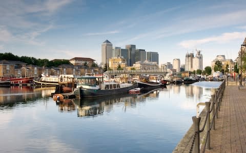
Uncovering the secrets of London's forgotten waterways

Exploring London’s network of canals, rivers and docksides is to walk (run or cycle) through the capital’s history. Towpaths, quays and riversides are soaked in traces of the past - from Saxon beaches, Georgian warehouses or Victorian sewer pipes to exotic plants carried on passing barges. Here are vivid visual aids to London’s rises and falls in fortune, invasion, trade and industry.
There are ribbons of almost-rural green, screened from surrounding suburbia by graceful willows and poplars, vast expanses of water where whalers, the first freezer ships, and ocean liners docked and canals that cut through key moments in industrial history. Gilly Cameron Cooper, author of Walking London’s Waterways, shares some of her favourite discoveries at water-level London.
1. Rotherhithe Peninsula
The Thames at Rotherhithe has teemed with the vessels of trade and adventure through the centuries. In 1620, the Pilgrim Fathers set sail from Rotherhithe for America in the Mayflower; thoroughbred 18th-century tea clippers strained at their moorings, before racing competitors to Australia; steamer packets ferried travellers to the Continent, and dirty British coasters carried cargoes of coal from the north.
Inland, great bodies of water were cut into docks. Massive blocks of granite that now edge an expanse of green park were once the quayside of Russia Dock. Greenland Dock is still a vast rectangular sheet of water. It was enlarged from one of London’s earliest enclosed docks that accommodated 120 sailing ships in the late 17th century, to become the main berthing for Arctic whalers, and later timber from the Baltic countries and grain from North America.

2. The marshy origins of the River Lea
Not far from the east London suburbs of Hackney and Homerton are expanses of marshland, where the River Lea cuts through banks inaccessible with a wilderness of vegetation. King Alfred the Great first drained and dammed the marshes at the end of the 9th century in a bid to redirect the upriver Lea to make it shallow and un-navigable for Danish invaders.
For centuries, commoners grazed their animals after the August wheat harvest (Lammas-tide) until the following April. Today, Belted Galloway and English Longhorn cattle have been reintroduced to restore the ecosystem of managed marshland that evolved – a haven for marshland plants such as flag, wild Michaelmas daisies and meadowsweet. The most luxuriant vegetation, though, is found in the Middlesex Filter Beds Nature Reserve. This was once a water-treatment plant built in the mid-1800s to purify the Lea’s water after a cholera outbreak claimed more than 14,000 London lives. An exotic fig-tree arches over a millrace that once provided power for a pins and needles-sharpening factory.

3. From Brentford to Hanwell Village
Among the industrial estates and sprawling suburbs below the M4 flyover are muddy, tidal backwaters and aits (islands) thick with trees, where the River Brent meets the Thames. The River Brent only became navigable in 1794, the final link in William Jessop’s Grand Junction Canal, which sliced 60 miles (100km) off the trade route between London and Birmingham.
Jessop’s pioneering Brentford Lock was double the usual width, able to take a single 70-ton Thames barge, or a pair of narrowboats simultaneously. Upstream, the towpath leads beneath skeletal ‘hanging’ warehouses, where Thames-going barges and lighters transferred their loads to the narrow canal boats. Hanwell Flight – a series of six locks on a bosky curve of canal – provides a visual lesson in how the lock system works over a steep gradient. Behind a high brick wall here, lies the 19th-century County Lunatic Asylum, innovative in its humane treatment of patients, and which had its own canal-side dock.

4. Mudchute and Millwall
What’s in a name? Mudchute, on the Isle of Dogs, is so called for chutes that carried the spoil from the excavation of nearby Millwall Dock in the 1860s, to the playing fields, parkland and a city farm that make up Mudchute Park today. Millwall was named for the granaries and silos of the McDougall flour family, pioneers of self-raising flour, which lined the dock throughout the 19th century and into the 20th.
The most thrilling historical moment on this route, though, is a giant ramp of horizontal timbers squeezed between Thames-side apartments. Here, in July 1858, thousands of spectators turned up to watch the launch of the largest ship in the world: Isambard Kingdom Brunel’s Great Eastern. It got stuck on that first attempt and wasn’t launched successfully until three months later.

5. The Working Wandle
Described in 1805 as ‘the world’s hardest working river’, the Wandle is a monument to Britain’s industrial history, and you can walk, run or cycle most of its length from the Thames at Wandsworth to Waddon Ponds. The Wandle’s outlet into the mighty trade route of the Thames had a strong, even flow that made it ideal for driving mills and attracted skilled Huguenot craftsmen exiled from Europe.
Street names, mill remains and industrial buildings evoke its diverse industries: beer (at the former Young’s Brewery), gunpowder (Wandsworth was England’s second largest producer in the late 17th C), snuff, chocolate, lavender, paper, and textiles at Merton Abbey Mills. Emma, Lady Hamilton diverted water from the Wandle waters to feed a canal cut through the grounds of Merton Estate, where she, her husband and Admiral Lord Nelson enjoyed a ménage a trois. And while that estate is long buried beneath hypermarket and housing, nearby, the Wandle still winds pleasantly through a stretch of green.
Buy a copy of Walking London's Waterways by Gilly Cameron-Cooper.