Wisconsin weather outlook: Snow total reports from Wisconsin, thundersnow in Madison and Green Bay, while Milwaukee gets rain
For an early April Tuesday that already featured Election Day, the Milwaukee Brewers' home opener and a trip to Green Bay by former President Trump, a winter storm hit Wisconsin. By the time it passes Wednesday, it could end up dropping a foot of snow on Green Bay and much of northeastern Wisconsin and leave a slushy, wintry mix in Milwaukee.
Here's a recap of Tuesday's eventful weather day:
10:15 p.m.: Thundersnow also reported in Green Bay
Following reports of thundersnow (when it snows and thunders at the same time) happening in Madison, the National Weather Service said there were also several reports of thundersnow on the east side of Green Bay.
Thundersnow occurs when the air is considered unstable if it continues to rise on its own after getting a nudge from a cold front or warm front. This is rare when it’s snowing due to the air temperature in winter snowstorms being consistently cold at both high and low points in the atmosphere.
But, in some winter storms, lower layers of warm air are lifted and continue to rise on their own, increasing snowfall and allowing for lightning to occur.
10 p.m.: Milwaukee to see a wintry mix overnight; snow for communities west of Milwaukee
A low pressure system with bands of snow sits out over Lake Michigan as of 9:45 p.m. Tuesday and will continue to make its way into Wisconsin overnight.
"We're expecting snow to continue off and on through the night and we may see some higher snowfall rates picking up after midnight, more so further west towards Madison, Wisconsin Dells, up towards Fond du Lac area," said Kevin Wagner, a meteorologist with the National Weather Service.
Wagner said the Milwaukee area, Racine and Kenosha will mostly see a wintry mix of rain and snow due to the warmer air. Wagner estimates that communities to the west, including Waukesha County, will see an additional 1 to 2 inches of snow fall overnight.
"We're looking at those heavier rains or heavier snowfall to kind of stay towards the Green Bay area, but sneak into Fond du Lac, to Madison, to the Dells area," Wagner said.
According to the measurement at Mitchell International Airport, Milwaukee has seen more than 2 inches of rain in the last 48 hours.
9:55 p.m.: Flood warning issued for the Fox River
The National Weather Service said the Fox River is near flooding and a flood warning has been issued until early Saturday afternoon for area along the river, from Waukesha to New Munster near the Illinois border.
9:45 p.m.: Here are the latest snow totals in Wisconsin
Here are the latest snow totals reported across Wisconsin Tuesday between 7 and 9 p.m. by the National Weather Service:
Omro: 7.4 inches
Hortonville: 6.3 inches
Waushara County: 6 inches
Horicon: 5.5 inches
Pardeeville: 4.9 inches
Wautoma: 4.8 inches
Beaver Dam: 4.6 inches
Mayville: 4 inches
Appleton: 3.5 inches
Green Bay: 2.2 inches
8:30 p.m.: Officials ask Milwaukee-area residents to conserve water use
The Milwaukee Metropolitan Sewerage District is urging Milwaukee-area residents to cut water use because of the combined sewer overflow initiated earlier today, caused by the rainfall. Residents in Milwaukee and its surrounding suburbs are asked to take shorter showers, and don't do laundry or the dishes.
Milwaukee has a combined sewage system in which both stormwater and wastewater from homes and businesses flow through the same pipes before it is treated. If heavy rains causes the water reclamation facilities and deep tunnels to fill to capacity, the sewerage district must discharge untreated water into Milwaukee’s three rivers and Lake Michigan to prevent wastewater from backing up into homes and businesses.
— Caitlin Looby
7:30 p.m.: Here are the latest snow totals in Wisconsin
Here are the latest snow totals reported across Wisconsin Tuesday between 4 and 7 p.m. by the National Weather Service:
La Farge: 7 inches
Montello: 5 inches
Oshkosh: 4 inches
Shorewood Hills: 4 inches
Appleton: 3.5 inches
Wautoma: 3.3 inches
Kronenwetter: 3 inches
Green Bay: 1.8 inches
5:40 p.m. Milwaukee sewers 76% full; combined sewer overflow initiated
Due to the onslaught of rain, Milwaukee Metropolitan Sewerage District initiated a combined sewer overflow at 5:40 p.m. to reduce the risk of wastewater backing up into homes and businesses.
The main deep tunnel had been 76% full, MMSD said. MMSD needs to reserve capacity in the tunnel for separate sewer flows from the suburbs. Federal law allows six combined sewer overflows per year.
4:15 p.m.: Weather service reports thundersnow in Madison area
There is thunder and snow at the same time in Madison area, said Andy Boxell, a National Weather Service meteorologist.
Boxell said the event is not common, but it does happen a handful of times across southern Wisconsin each winter. "It's almost always with a system like this that's very dynamic, and it has these heavy bands of snow that are strong enough to eventually generate some lightning," he said.
Thundersnow is appearing on radar through cloud coverage at the Madison airport, but Boxell said he wouldn't be surprised if people are hearing thunder from Sheboygan, through Watertown and Janesville.
Volume up!
Thundersnow in Janesville, Wis a bit ago! #wiwx #thundersnow pic.twitter.com/JhI27kun1o— Tom Purdy (@TomPurdyWI) April 2, 2024
Thundersnow occurs when the air is considered unstable if it continues to rise on its own after getting a nudge from a cold front or warm front. This is rare when it’s snowing due to the air temperature in winter snowstorms being consistently cold at both high and low points in the atmosphere.
But, in some winter storms, lower layers of warm air are lifted and continue to rise on their own, increasing snowfall and allowing for lightning to occur.
3:45 p.m.: Winter storm warning expands in central Wisconsin, northeastern Wisconsin rain transitions to snow
The National Weather Service expanded its winter storm warning at 2:45 p.m. to Dane County.
The latest forecast from the Milwaukee office of the NWS said that additional snow accumulations between 4 to 7 inches were possible through 7 a.m. A subsequent winter weather advisory is in effect from 7 a.m. Wednesday until 1 p.m.
The winter weather advisory said that additional snow accumulations of up to 2 inches are possible during that time frame, with wind gusts up to 40 mph.
The NWS said on X, the former Twitter social media platform, that snowfall rates were at about 1inch per hour. The weather was leading to difficult travel, with reduced visibilities and slippery roads.
Snow will continue for most through 5 PM. Accumulations on roads, especially on ridgetops and overpasses. 1" per hour rates will continue under heavier snow bands. Reduced visibilities and slippery travel are expected. #wiwx #mnwx #iawx pic.twitter.com/lnm3tgkN5f
— NWS La Crosse (@NWSLaCrosse) April 2, 2024
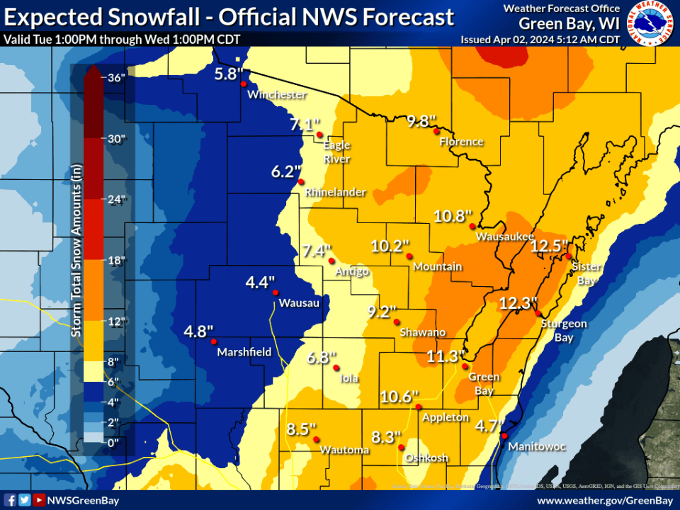
The Green Bay NWS office said on X that the day's rains had switched to snow in that part of the state. Large swaths of that part of the state are expected to receive between 6 to 12 inches of snow, with higher amounts possible in some areas.
The NWS has issued a winter storm warning for much of the area.
Much of the precipitation has changed over to snow already this afternoon, but areas right along Lake Michigan are still seeing mainly rain. As snowfall picks up this evening and temperatures start to fall road conditions will rapidly deteriorate making travel hazardous. #wiwx pic.twitter.com/hfSURFuCRf
— NWS Green Bay (@NWSGreenBay) April 2, 2024
2:30 p.m.: Upper Peninsula snow forecast shows over 2 feet of snow possible in some areas
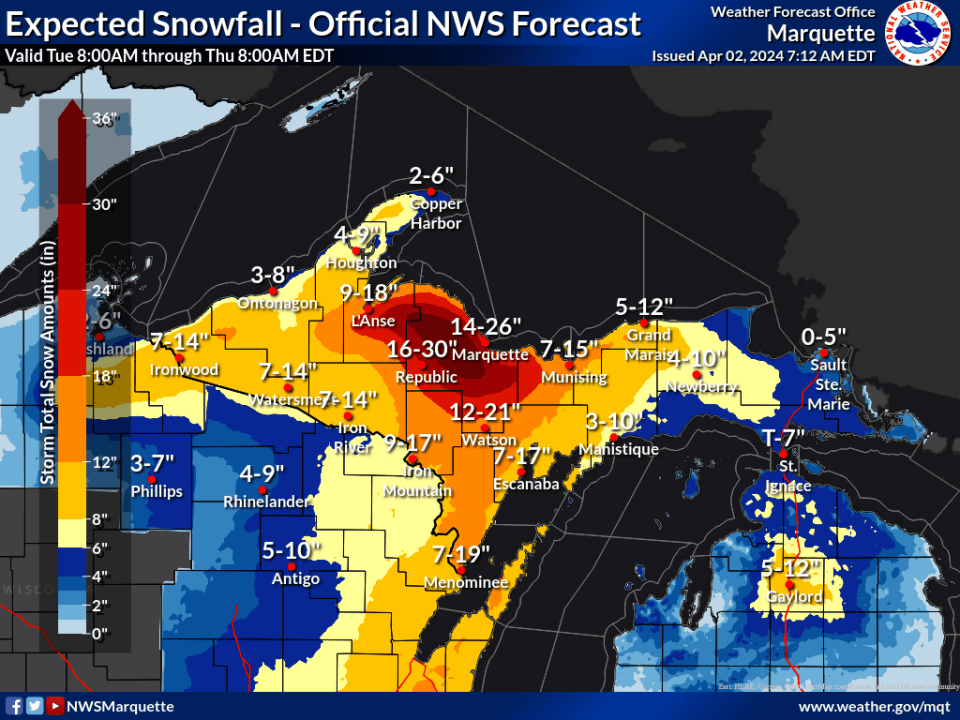
Parts of the Upper Peninsula could see up to 30 inches of snow in the high terrain areas of Marquette and Baraga Counties into Thursday morning.
The Marquette, Michigan, National Weather Service office issued a blizzard warning for the region, with 8 to 12 inches of snow likely for a large swath of the area. A large contrast is possible in the region, with areas closer to Lake Superior forecasted between 6 to 8 inches of snow and Marquette and Republic, Michigan, forecasted for 14 to 26 inches and 16 to 30 inches respectively.
The system is expected to come with sharp winds of up to 45 miles per hour and possibly higher near Lake Superior. The blizzard warning said that travel could be "very difficult to impossible" and that power outages were possible.
Strong northerly winds, gusting 35-45 mph coupled with heavy snow will enable Blizzard conditions over Baraga and Marquette Counties from later this evening through Wed. Whiteout conditions are expected along with possible power outages. Wet and heavy snow is likely. #906 #MIwx pic.twitter.com/EjEDxefWkm
— NWS Marquette (@NWSMarquette) April 2, 2024
It's not uncommon for the region to see high snowfall projections like this in early spring, said Jonathan Voss, a meteorologist in the office.
A year ago, on May 1, a snowstorm dumped almost 20 inches, breaking the daily record for the area, he said. In total, that system brought almost 30 inches of snow to some parts of the area.
"We can definitely get these stronger late seasons storms," Voss said. "The impacts when you get into the later seasons, its greater from how wet the snow (is.)"
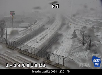
1:35 p.m.: Road conditions begin to deteriorate from slushy snow
This webcam shot from our partners at @WisconsinDOT shows how the slushy snow on area roads can still cause you to lose control so we urge people to slow down and use caution until this new snow melts. In some areas the snow will continue into tonight. #wiwx pic.twitter.com/YntELoxrpM
— NWS La Crosse (@NWSLaCrosse) April 2, 2024
The Wisconsin 511 road condition website showed expanding "slippery stretches" throughout central Wisconsin, with WIS 21 closed near Tomah due to a car crash.
The La Crosse National Weather Service office said on X, the former social media platform, that several accidents had occurred in the area's ridgetops in La Crosse and Vernon counties.
Lower temperatures in those areas were leading to greater snow accumulations, the NWS said.
[1:20 pm] Reports of more numerous accidents on the ridgetops in La Crosse and Vernon counties in western WI. Because it is slightly cooler on ridgetops, the snow is accumulating a bit more there (1-4" so far). Expect to see snowy roads on higher terrain, and slow your speeds! pic.twitter.com/2EVcvgWoNh
— NWS La Crosse (@NWSLaCrosse) April 2, 2024
12:45 p.m.: National Weather Service expands warning, advisory as snow comes heavy
The La Crosse office of the National Weather Service issued an expanded winter storm warning in central Wisconsin as snow was falling heavier than anticipated.
Initial snowfall totals in La Crosse, as of 12:51 p.m., were at 4.6 inches. To the north, in Thorp, 3 inches of snow was reported.
The most recent warning from the La Crosse office, issued at 11:38 a.m., was for Juneau and Adams Counties and said that heavy snow was forecasted for up to 7 inches, with the majority falling Tuesday night. The alert lasts through 7 a.m. Wednesday and said that wind gusts could be up to 45 mph, with visibility being impacted.
?????Update: Due to heavier snow amounts, Central Wisconsin counties have been upgraded to a Winter Storm Warning and Winter Weather Advisories have been expanded further west. These alerts go through Wednesday morning. Use caution if travelling. #wiwx #mnwx #iawx pic.twitter.com/HaTLX7ydm9
— NWS La Crosse (@NWSLaCrosse) April 2, 2024
Tuesday evening and Wednesday morning commutes in central Wisconsin could be affected and there is potential for the heavy snow to bring down tree branches and power lines, NWS said.
The NWS also expanded its winter weather advisory area into La Crosse and Crawford counties, with snow accumulations expected between 2 and 4 inches. Winds in that area are expected to reach 45 mph as well.
In southeastern Wisconsin, the NWS is now forecasting widespread snow beginning at 6 p.m.
We're monitoring the rain / snow line as it progresses southeastward into our forecast area. These slides show our estimate for when it will pass through. More graphics like these can be found in our latest information packet: https://t.co/9rYLedduQF pic.twitter.com/3EO93Xeuhd
— NWS Milwaukee (@NWSMilwaukee) April 2, 2024
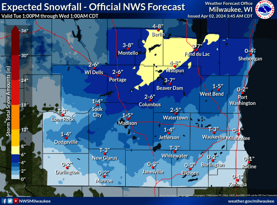
Milwaukee is just outside of the snow band and forecasted for between 0 and 2 inches through Wednesday morning. Other areas to the west and northwest, like Waukesha and West Bend, are expected between 2 and 4 inches and further south in Racine and Kenosha is between 0 and 1 inches, according to the NWS.
11:15 a.m.: Snow transition begins in central Wisconsin
Tuesday's snowstorm began its transition from rain into snow at about 11 a.m. northwest of the Wisconsin Dells, according to Madison news station WMTV-15.
11AM - The transition to snow has begun northwest of the Dells! Some snow is sticking to overpasses near Camp Douglas but roads are reported to be in good shape still. #wiwx pic.twitter.com/Rqp4vXt16s
— WMTV 15 News (@wmtv15news) April 2, 2024
The La Crosse office of the National Weather Service forecasted at 7 a.m. that central portions of the state, like the Wisconsin Dells, would see 6 to 8 inches of heavy, wet snow. Madison is projected for between 4 to 6 inches, while areas just north and south of the Dells were projected for between 2 to 4 inches of snow.
Snow will continue for most through 2 PM. Accumulations on roads and 1" per hour rates will continue under heavier snow bands. Reduced visibilities and slippery travel are expected. #wiwx #mnwx #iawx pic.twitter.com/Mi5jgl453X
— NWS La Crosse (@NWSLaCrosse) April 2, 2024
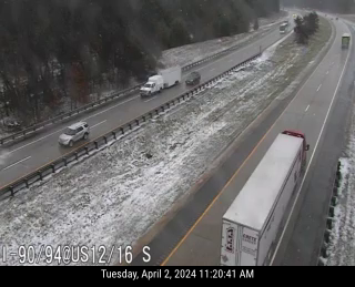
The NWS forecast expected the snow to begin in the afternoon and peak in the late afternoon and evening. Images on the Wisconsin 511 road condition website showed snowfall around 11:20 a.m. in the Wisconsin Dells area.
[10:15 am] A heavy snow band will stripe the state of WI today. Rain will change to snow, and when it does, there could be heavy snow rates (1+ in. per hour) at times this afternoon & eve. Here is a rough location and timing of that heavier snow (bright oranges): pic.twitter.com/ZqinpOg2WC
— NWS La Crosse (@NWSLaCrosse) April 2, 2024
6:35 a.m.: Northeastern Wisconsin forecasted for heavy snowfall this evening
The Green Bay National Weather Service is expecting snow to begin midafternoon and reach its peak on Tuesday night and into Wednesday morning.
Snow accumulations are expected for over a foot in Sturgeon Bay, between 10 and 11 inches in Appleton and Green Bay, and around 4.5 inches to the west in Marshfield and Wausau. With those higher totals, the office has issued a winter storm warning for a segment of northeast and central Wisconsin, upgrading from an earlier winter weather advisory.
"There's a lot of moisture with this system," said Tim Kieckbusch, a meteorologist at the Green Bay NWS. "It looks like especially this evening."
An early Spring snow storm will begin impacting the region this afternoon and continue through Wednesday. Potential accumulations to range from 4 to 8 inches over central WI and 8 to 14 inches over eastern WI. Strong winds, gusting 30 to 50 mph, will make travel difficult. #wiwx pic.twitter.com/dmn930Wx4Q
— NWS Green Bay (@NWSGreenBay) April 2, 2024
He said that it isn't uncommon for early spring low-pressure systems to develop with high moisture levels like this.
6 a.m.: Weather system shifts west, bringing lower snowfall forecast to Milwaukee than initially expected
Here is the forecasted snowfall accumulation map for this afternoon and evening. There will be light snow afterward late tnt-Wed nt and windy. #swiwx #wiwx pic.twitter.com/OuVojoBlAK
— NWS Milwaukee (@NWSMilwaukee) April 2, 2024
On Monday, forecasts showed that that the Milwaukee area could get up to five inches of snow, however the weather system’s movement to the west has lessened that.
The latest projections forecast that Milwaukee could receive up to two inches of snow now.
“The rain, it will change to snow kind of real late in the afternoon, but by then a lot of the heavy (precipitation) will have moved away,” said Mark Gehring, a local National Weather Service meteorologist. “There could be a little bit of grassy accumulation, in the western-northern portion of the county.”
Another major factor in the new forecast is the expected temperatures of the day keeping the storm’s precipitation mostly rain in the area, he said. Areas near Waukesha and the Timmerman Airport have the highest chances of receiving slight accumulation totals.
“(The system) has shifted even further west, which is why Milwaukee is going to get mostly rain now,” Gehring said. “It does strengthen very well from early this morning into the evening. There is going to be a good heavy snow band … the further west you go, the greater chance you’ll have problems.”
Rain changing to wet, heavy snow this afternoon. Winter Storm Warning north of Madison and toward east central WI for 4-8 inches. A Winter Weather Advisory for other portions of S WI. See graphic for details. #swiwx #wiwx pic.twitter.com/RAuGbdFy3I
— NWS Milwaukee (@NWSMilwaukee) April 2, 2024
However, with the storm's movement west, it means that Madison, the Wisconsin Dells, Beaver Dam, among others, are in a winter weather advisory, with up to four inches of snow possible in that area. Further north and east, totals reach eye popping numbers of over a foot of snow possible.
5:30 a.m.: Northeastern Wisconsin could see up to 14 inches of snow, surrounding areas between 8 to 12 inches
The National Weather Service issued a winter storm warning and predicted between 8 and 12 inches in northern Wisconsin, with up to 14 inches possible in the far northeastern portion of the state.
With it, wind gusts could reach 45 miles per hour, leading to areas of blowing and drifting snow. Affected areas include Appleton and the surrounding areas, with higher totals possible near Green Bay.
Snowfall rates are expected to reach more than an inch an hour on Tuesday evening, the NWS said.
The NWS warned that strong winds and heavy snow could down power lines, potentially causing sporadic power outages. Travel is expected to be very difficult and impacting Tuesday evening and Wednesday morning commutes.
The heavy snow comes as former president Donald Trump is scheduled to visit Green Bay for a campaign rally at 5 p.m. at a local hotel.
5:30 a.m.: Snow could put a damper on Brewers' opening day, election day
The latest forecast from the local NWS office shows that just as tailgaters head inside for the Brewers home opener at 3 p.m. the rain will be turning to snow.
That will continue on and off into Wednesday afternoon, potentially leaving behind 2 inches of wet, slushy snow that should melt quickly. The greatest impacts are expected to be between 6 p.m. and through noon on Wednesday, the NWS said in an update on Monday afternoon.
The latest forecasted totals from the National Weather Service show that Milwaukee could see less snow than was initially forecasted on Monday.
5:30 a.m.: Winter weather advisory issued north of Milwaukee
Tuesday's snowfall could bring between two and six inches of snow and winds as high as 45 miles per hour to an area just north and west of Milwaukee, the NWS said.
Affected communities include Sheboygan, Fond du Lac, West Bend, Medford, Neillsville, Black River Falls, Sparta, Tomah, Mauston, Friendship, Viroqua, and Richland Center.
The advisory is in place between 4 p.m. and 7 a.m. on Wednesday.
Snow expected hit Wisconsin Tuesday afternoon, last through Wednesday
Snow is expected to start accumulating Tuesday afternoon throughout Wisconsin, according to the National Weather Service, with rain turning to snow in the Milwaukee area and southeast Wisconsin.
The heaviest snowfall is expected from late Tuesday afternoon through early Wednesday morning, but snow will likely continue through Wednesday.
The NWS in Sullivan projects a 24% chance of at least 4 inches of snow in Milwaukee, with higher percentages to the west and north.
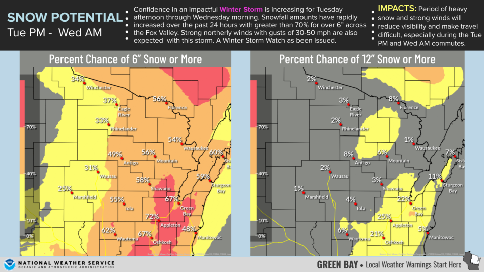
The NWS in Green Bay says the most likely area to get at least 6 inches of snow is a band that runs from the Fond du Lac area north to the Green Bay area, including Oshkosh and Appleton. There's a 20-25% chance the area will get 12 inches of snow.
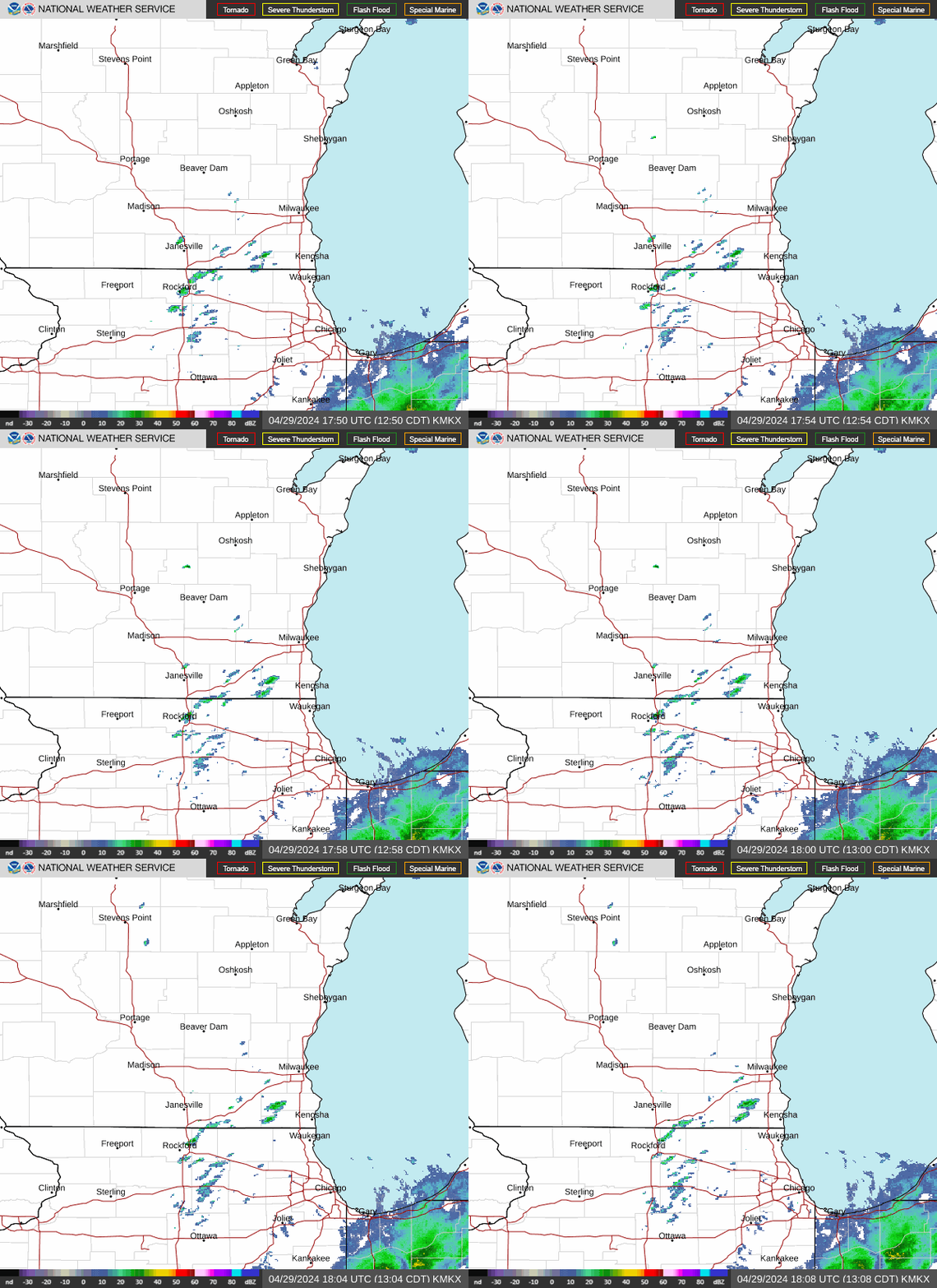
Wisconsin weather radar
Wisconsin weather warnings
This article originally appeared on Appleton Post-Crescent: Wisconsin weather outlook: Thundersnow in Madison, Green Bay area
